

Photo Record
Images
Metadata
Title |
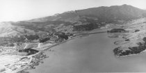
Aerial view of Richardson Bay area, circa 1950s |
Type of Object |
Print, Photographic |
Object ID |
MVU2686 |
Collection |
Photographs |
Description |
Richardson Bay is in the center foreground with Strawberry Point to the right of it. Marin City housing is at left center, Marinship is in far left forground. Richardson Bay Bridge crosses to DeSilva Island in center. Mill Valley is in the background at the base of Mt. Tamalpais. |
Physical Description |
1 photographic print, b&w, 9.5'' x 5'' |
Date Created |
circa 1950s |
Year Range from |
1950 |
Year Range to |
1960 |
Creator (Artist/Author/Photographer) |
unknown |
Contributed by |
Little, Lucretia Hanson |
Search Terms |
Aerial photographs Aerial views Bridges Richardson Bay Richardson Bay Bridge Strawberry Point |
Copyright |
Copyright status unknown. Some materials in the Lucretia Little History Room digital collections may be protected by the U.S. Copyright Law (Title 17, U.S.C.). In addition, the reproduction and/or commercial use of some materials may be restricted by gift or purchase agreements, donor restrictions, privacy and publicity rights, licensing agreements, and/or trademark rights. Distribution or reproduction of materials protected by copyright beyond that allowed by fair use requires the written permission of the copyright owners. Responsibility for obtaining permissions and for any use rests exclusively with the user. |