

Photo Record
Images
Metadata
Title |
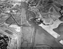
Aerial view of Mill Valley, 1963 |
Type of Object |
Print, Photographic |
Object ID |
MVU1558 |
Collection |
Photographs |
Description |
Aerial view of Mill Valley taken in September 1963. Northwestern Pacific Railroad tracks run at far left from the bottom of the photo to the top. Miller Avenue curves up from the bottom next to the tracks and heads toward downtown Mill Valley. The city corporation yard is at upper left beside the railroad tracks and joined is by Sycamore Avenue to Camino Alto Avenue, which runs across upper left corner of photo. Housing at the right is Enchanted Knolls. Shelter Bay would later be located on the excavated area of hills at center right. Tamalpais High School's football field and track are seen at lower left near Miller Avenue. |
Physical Description |
1 photographic print, b&w, 6.5" x 8.5" |
Date Created |
1963-09-18 |
Creator (Artist/Author/Photographer) |
Aero Photographers |
Contributed by |
Little, Lucretia Hanson |
Site Name |
Lane |
Search Terms |
Aerial photographs Aerial views Camino Alto Enchanted Knolls Miller Avenue Railroad tracks Sycamore Avenue |
Copyright |
Copyright status unknown. Some materials in the Lucretia Little History Room digital collections may be protected by the U.S. Copyright Law (Title 17, U.S.C.). In addition, the reproduction and/or commercial use of some materials may be restricted by gift or purchase agreements, donor restrictions, privacy and publicity rights, licensing agreements, and/or trademark rights. Distribution or reproduction of materials protected by copyright beyond that allowed by fair use requires the written permission of the copyright owners. Responsibility for obtaining permissions and for any use rests exclusively with the user. |