

Archive Record
Images
Metadata
Title |
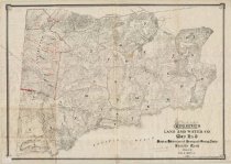
Tamalpais Land and Water Co. Map No. 3 Showing Subdivisions of Farming and Grazing Lands, Sausalito Ranch, 1892 |
Collection |
Maps |
Scope & Content |
Tamalpais Land and Water Company Map No. 3, 1892. A map mounted on posterboard showing subdivisions of farming and grazing lands of the Sausalito Ranch, with annotations in red. Duplicate of map #464 |
Creator |
Clapp, Chas. H., Civil Engineer |
Extent and Medium |
1 map; 1 sheet(s), 27.75"x42" |
Search Terms |
Farmland Sausalito Ranch |
Object ID |
2015.043.080 |
Object Name |
Map |
Copyrights |
Copyright status unknown. Some materials in the Lucretia Little History Room digital collections may be protected by the U.S. Copyright Law (Title 17, U.S.C.). In addition, the reproduction and/or commercial use of some materials may be restricted by gift or purchase agreements, donor restrictions, privacy and publicity rights, licensing agreements, and/or trademark rights. Distribution or reproduction of materials protected by copyright beyond that allowed by fair use requires the written permission of the copyright owners. Responsibility for obtaining permissions and for any use rests exclusively with the user. |